B.Heys
Over the last few years, small parties of N.P.C. members have wandered around the headwaters of the Swale, Eden and Rawthey in search of new caves.
Although we cannot yet claim any great new discovery, the total length of new oddments in the area now exceeds a mile. In the eastern part of the area the caves are in nearly horizontally bedded Great Limestone and such as we have found have been explored for the best part of their length.
In the west, near the Dent fault, the caves are in steeply dipping beds of limestone and we are far from understanding the geology and hydrology of the area. Nevertheless it seems that there is a possibility of extensive caves in this area of which we have so far only found small fragments.
I think my first serious especition to the area was March 1960 when, on instructions from Jack Myers, I went to investigate the headwaters of Great Sleddale Beck. An outcrop of the Great Limestone at 1700' O.D. gave a possibility of an inter-dales cave system - I chose to approach it by walking over from Hell Gill in Mallerstangdale.
Hell Gill we found to be a very fine ravine, practically an open air pothole, but on this occasion the snow was melting so we did not attempt to explore it.
The Great Sleddale Pots (827 988) are shown on the 1" map as a number of sinks on the south side of the main beck. They are just above a scar marking the line of a mineralised fault and nearby is a copper mine, the only one in the Dales area justifying mention in the geological survey report on copper mines.
One of the shakeholes which swallows quite a large stream has impressive rock faces at the east end but can easily be descended at the west end to a depth of about 40 ft., at which point a 20 ft. ladder is required to negotiate an awkward overhang. A gradually diminishing passage continues to a depth of about 70 ft.
It could perhaps be pushed further but the stream obviously surfaces at the foot of the scar and doesn't merit much effort.
In the next few hundred yards eastwards along the hillside are a few other holes, one of which also requires a ladder, but none of them have the makings of an inter-dales cave system.
With May and warmer weather we were ready to think about Hell Gill (787 968). We started with a reconaissance in the upstream direction, a few deep potholes to wade (if yoiu can find and balance on the footholds under about 4 ft. of water) and a couple of waterfalls to be climbed to a very deep pool, at the other side of which is a very smooth waterfall, obviously our limit. Attacking from the top end we slithered down polished slabs and splashed in pools till we came to the top of this waterfall; a plunge, a quick frantic swim and we were safely on the other shore and able to complete a through trip.
Although it is possible to climb out at some intermediate points, the length of the ravine is about a ¼ of a mile and it makes a pleasant pseudo caving trip without the encumbrance of lights. The recommended equipment is boots, overalls, swimming costume, helmet and a lifeline for the plunge. A bridge across the ravine at about its deepest point can be the start of a pleasant ladder climb. In fact it offers all the potholer could desire, except mud.
Northwards from Hell Gill for 1½ miles are several sinks and shafts, only one of which requires a ladder. That one was, however, so split up that we had to hang the ladder down 3 different routes to make sure we had covered all possibilities. It was an excellent day while we were looking at these holes and we found a most abundant whinberry bush. Having exhausted the bush and the potholing potentialities we went for a walk onto Mallerstang Edge and lazed in the sun. In the distance was a small patch of dark cloud which seemed to be heading in our direction so we eventually decided to return to the cars. As the cloud got closer, so our speed increased until we were about a ¼ of a mile from the cars and running when the rain began. At this point we saw a hole in the ground with a stream running over a dead sheep and an obviously negotiable passage. We carried on running.
It was October before we decided to have a look at this hole - Eden Sike Cave (781 969). I started off upstream with Malcolm Birley. The first 50 ft. was about 3 ft. high and by traversing, I managed to keep my feet dry. The roof then dropped to about 18" and it widened to about 6 ft. Nothing really to deter the average potholer. I had my best anorak on so was not keen to mess it up, however there was no harm in pressing on a bit.
The passage gradually gained height and became more of a fissure type with occasional deep pools, till I was thoroughly soaked and my anorak badly ripped. The passage continued but getting tighter, so we set off back.
Meanwhile Alan Fincham had attacked the downstream end and forced a very wet way through to daylight the other side of the wall, after which he came to meet us in the upper section. When we met we decided to get the survey equipment from the car before finishing to the end.
Malcolm didn't fancy a second trip in, so Andrew Lord joined us instead. We used a lump hammer liberally to ease our way near the end. Nowhere was there any great difficulty yet there was no sign of anyone else having been in.
Our limit was a chamber with a 12 ft. waterfall, the stream entering through a narrow fissure in the roof and not looking promising. We noticed another inlet passage but as it was rather low, we left it for another day. When we finally had a look at in March 1961, we added another 50 yards to a definite sump.
We had another attempt to push this early in 1967, but having no success we wandered over to look at Jingling Sike Cave (787 966) which I thought would yield a through trip. We started from the top end with Gordon Batty, and me in the rear. When going got desperate we retreated and had a go at the bottom end, where we made contact with Eski. With melting snows it earned a classification as S.S.C.
In January 1961, Gordon Batty, Colin Green and Geoff Hart spent a bit of time in Cotterdale, finding a very wet cave issuing into Dry Gill. There was very little airspace so they did not pursue it very far.
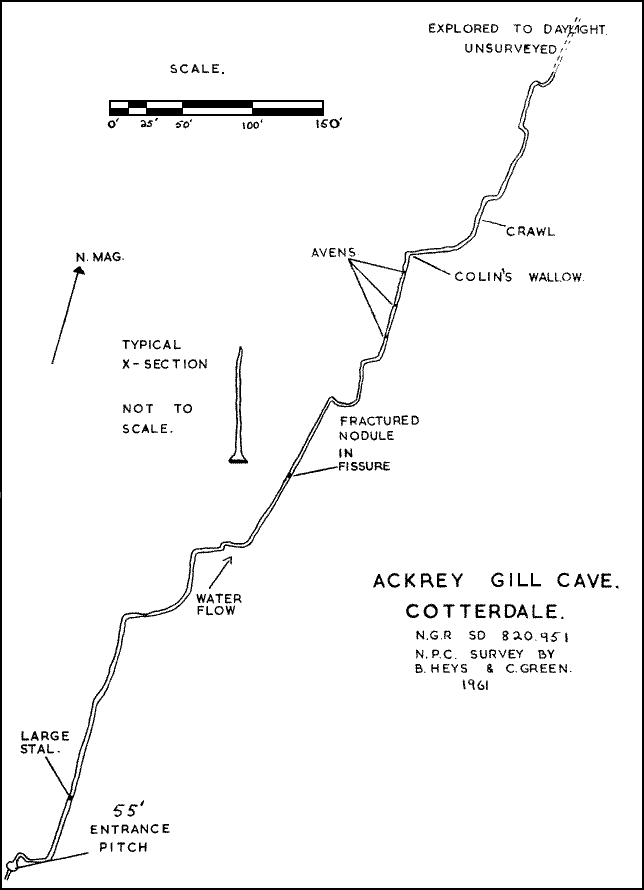
They also opened up a shaft a short way north of the sink of Ackrey Gill (820 951) which gave a 50 ft. ladder climb down a tight fissure to a stream passage. Colin Green asked to borrow the end of my survey tape and dragged me through to a point where daylight could be seen, although we were not able to emerge.
For the most part the passage is very high but also very narrow so that it is necessary to crawl in the stream where it is wider. One interesting feature we noticed was a chert nodule which was embedded in the two walls of the rift and had fractured, showing a 2" gap between the matching faces. This would be the original opening of the limestone fissure which by solution had created the cave.
1966 saw a renewed attack on Dry Gill Cave (821 944). Eski and I improved the air space and were able to continue for a hundred yards or so into higher passages which split up and became narrow, but could perhaps be pushed further. We also looked at a few shafts near the sink a ¼ of a mile to the south which feeds the system. One at least might go, but it is rather tight and awkward.
The caves described so far have all been very predictable. It has been very much a case of looking at a 2½" map for sinks and risings in the Great Limestone and then following the stream through.
Over on the western slopes of Wild Boar Fell, the position has been very different. My interest in the area started by spotting a large rising marked on the 6" map in Needlehouse Gill (738 972). On the north side of the gill the water issues from boulders at the foot of a steep boulder slope, not a hopeful dig. On the south side the water emerges from small cave openings in a cliff, which have been pushed for 100 ft. among rather loose blocks.
The geological evidence suggests very strongly that the source of this stream is largely from sinks in Scandal Beck (757 997). A shaft of 30 ft. in the stream bed has been descended but does not offer much hope. Other sinks on about the 1600 ft. contour may be expected to join the system.
Below this level and away from the Great Limestone there are many other sinks whose ridings cannot be predicted with any confidence.
There are sinks in Clouds Gill (738 992) and the neighbouring gill (738 991) which are probably joined by the waters of Deep Moss Pot (740 995) and Greenrig Pot (736 021) in the same tilted bed of limestone to form a substantial stream.
Apart from the Needlehouse Gill rising, which is unlikely from geological considerations, the only adequate rising north of the Rawthey to account for this is Keld Head (737 021), but even this is unlikely since it is not peaty and probably attributable to drainage from the limestone scars of Stennerskeugh Clouds or sinks in the lower reaches of Scandal Beck. There may be an as yet unrecognised rising in one of the deep pool at Rawthey.
At a still lower level we have the waters of Black Moss Pot (723 982) and its neighbouring sinks which probably go to a rising near the Rawthey at (722 973).
North of Wild Boar Fell we have a major sink at Whorn Gill (760 027) which together with Christy Gill (761 030) probably drops down to the Eden to the vicinity of Blea Pots Lumb (775 050).
To the south-west there is the Bluecaster system which almost certainly extends in a nearly straight line from sinks at (712 955) to the Rawthey Cave rising (718 973) with many shakeholes on the way.
Having summarised the hydrology and possible potholing potential of the area we can move on to consider how much cave has actually been explored and alas show how little theorising has helped in its discovery.
Once it had been proved that caves existed at the Needlehouse Gill rising, a party of potholers were persuaded to go up there. One of their number, who was not capable of recognising the Great Limestone, the only decent cave bearing Yoredale limestone, noticed a small hole on the way, in an insignificant bed of thin limestone and promptly discovered Chert Cave (734 971) which has been surveyed to 1571 ft. and to be the most extensive in the area. There is a small stream issuing which is probably easily accounted for by sinks in the immediate vicinity.
Greenrig Pot was discovered in a very similar manner; we were on our way to the Scandal Beck sinks, glancing casually at shakeholes in the thin beds of limestone on the way. John Parkinson called to us that he had found an open hole and as we had ladders with us we went down and explored 450 ft. of passage including some large chambers. These chambers with avens probably correspond to the neighbouring shakeholes. One contains a large stalagmite.
One very significant feature about the entrance shaft is that it shows, apart from a thin shale band, a continuous depth of 50 ft. of solid limestone whereas the geological survey indicates that there are only two thin beds of limestone between shales here. The stream is flowing south westwards and although it is only a small one it is likely to join the major stream sinking in Clouds Gill nearly in the same band of limestone.
Featherbed Pot (750 997) was also found on a trip to Scandal Beck. Although there is only about 50 ft. of passage it is quite large in section. It does not have any significant drainage. It is probably in the Undersett Limestone and its existence is therefore not too much against theory.
All the other caves mentioned above in this area are in fact as yet of very limited extent, but represent working faces from which we might expect an N.P.C. breakthrough any decade now.
Just for completeness sake - but not laying claim to any discovery - we will mention at the southern end of the area:-