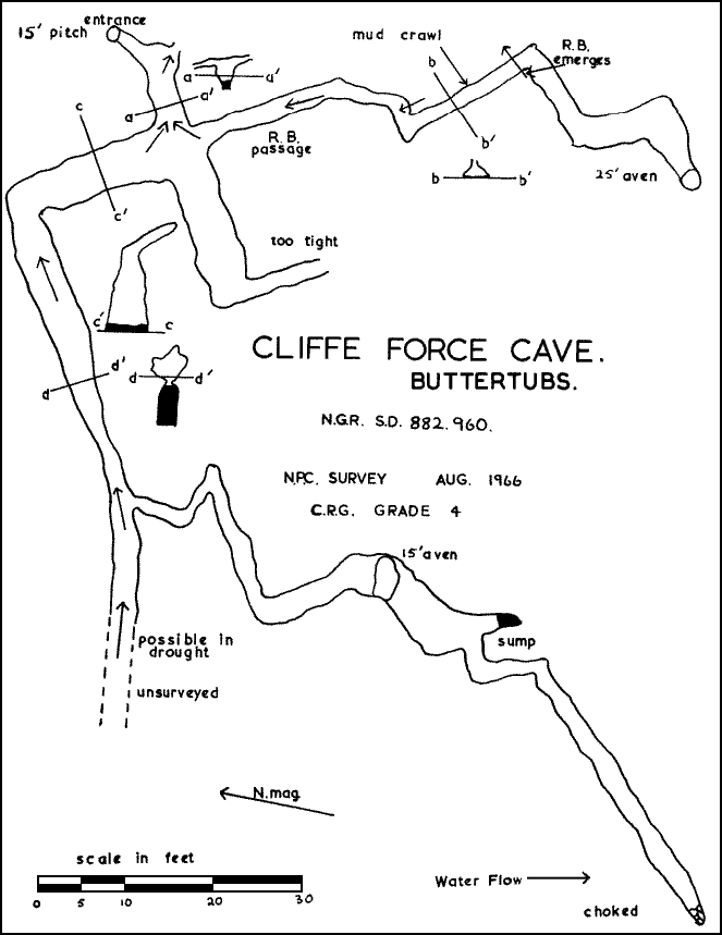
Cliffe Force ranks as one of the major digs of the club and has produced more diggers and subsequently lost more probationary members than any other dig. Many thoughtful looks and wishful thinking and five years of sporadic digging have been indulged in. A small outcrop of limestone is flanked on both sides and above by glacial drift and is no more than 50 feet wide and 50 feet high, typical Yoredale. Fronting this is a 30 foot stretch of turf riding to within 15 feet of the tip of the limestone. This is on the right, but on the middle higher outcrop, there is only 8 or 10 feet of turf, while on the left no more than 15 feet of outcrop and very little turf. Across the face and below the turf at least 20 feet of rubble emerges. Below this, water emerges at different levels across the whole face, and there is no sign of cave development.
Three major attempts to crack this system will be mentioned. J.O.Myers and A.Fincham dye tested shakeholes 400 yards east of the rising. These reappeared in Lover Gill. A sink, above and 20 ffet from the edge of the scar reappeared on the left of the scar. A dig here produced a 35 foot shaft and with the sound of a waterfall in the distance. However, the bottom became restricted and during the week massive infilling reblocked this and, capped by a 4 foot by 16 inches thick slab of sandstone, finished this for the time being.
Another attempt by the Settle (G.Batty, C.Green, B.Hart and J.Hart) team was to drive a 12 foot level on the extreme left where the Rhodamine B resurged. They were warned that this would produce 144 cubic feet of rubble - it did ! A lone visit was made, observation on the right of the scar showed 10 feet of vertical joint (at the tip of the turf). Could this extend below the turf for the whole height of the limestone ? Examination of the rubble showed that water could be heard above the resurgent point, and this in direct line with the joint. A trial level was driven in at the base of this joint, this draughted. J.O.M. was asked for his opinion and he rightly pointed out that there were many joints with draughts. However, another visit and yet another level, this to check the continuation of the joint, and yet another small one to gauge the depth of the turf. A spot was selected in direct line of the joint and the last sound of water, and a massive level was then driven into the turf. K.Ashton, A.Fincham, A.Kirk and a friend were then persuaded that the National Health would treat apocryphal blisters free and about 8 to 12 tons of rubble were removed. A continuation of the joint was revealed and a shaft ! This was dry walled and capped.
Twelve months later, an aspiring Pennine member found this and told his friends at the Green Dragon that he had found a new cave. He probably thought the dry walling a natural feature of the cave.
Due to the mess caused by digging, six packets of assorted seeds were sown. These were promptly eaten by sheep before they had matured. At the bottom of the shaft were twin passages, left and right, both with separate streams. The left one carries surface water from the shaft above Rhodamine B passage. The right hand one in dry weather carries the bulk of the water and is well developed. This closes down to inches of airspace. This was pushed by Fincham who reported that it was a backwater with the main stream coming in on the left underwater. A left hand oxbow was forced and this showed a continuation of the main stream, but this had even less airspace. M.Boon, C.D.G. gave assistance. This proved hopeless, water coming in from a narrow bedding. Much work was done digging out passages around this point, more work was done opposite the bottom of the shaft. Strong breezes can be felt in this heavily cross-jointed, small, mud-filled passage. Equipment put down inadvertently, vanishes. Other features are albino worms in the mud banks. R.B. passage led off from this well above the floor. Was it important ? A visit in flood conditions said yes. Water was coming out of this passage, obviously main stream water. Work was then started on excavating this. Due to the entrance tube being restricted by mud and stones, B.Heys constructed outside, a dam, tapping the water from surface drainage which supplied the shaft. From this, a hosepipe led into the cave, giving a head of 50 feet. We tried to use this to wash out the mud. However, subsequent chemical reactions opened up the further reaches which gave sufficient head of water in flood whcih blasted this clear. A left turn was, after months of work, cleared of mud. Water welling up in the floor here caused a great deal of trouble, for each blow struck at the drill, there were umpteen gallons displaced. This can be upsetting in a confined space. A man-made chamber gave sufficient room to attack two small holes, from which a gale issues and the sound of a waterfall can be heard. After untold heart attacks, bleeding knuckles and heartd, the two became one, no comment !
During this time two rock falls were heard and although the gale continued and blew out candles, the waterfall became mute.
This passage was then forced. A 25 foot aven was climbed, with 25 feet of drift neatly stacked alongside, there was no way over. The way on is down through the drift, and there should be a sizeable passage very near. Due to possible shuttering from the drift, some way must be found to make this safe.
Sixteen consecutive weekends were spent in opening up the last 15 feet of passage. Blizzards, frozen beards and clothes make this a place to avoid in winter.
It does seem that, since there is 4 feet of water coming from R.B. passage and same from the other main passage, neither being sluggish, that a larger passage is near. However, the development, although good, does not justify the amount of water coming from this cave. There is a well-defined ravine about 200 feet away - could this be the original cave entrance ? The back end of this is heavily glaciated.
References
J.O.Myers, The Major Underground Drainage Systems in the Yoredale Limestone of the Askrigg Block N.P.C. Journal Vol. 2 No. 3, 1963
"Sink in Sargill at SD 879932 at 1730' to Cliffe Force, SD 882960 at 1500' a fall of 230' in a distance of 1 ¾ miles. Fluorescein tested 5th-7th April 1959. Also good evidence of water collected from the area of Little Moss over 2¼ miles away from Cliffe Force."