J.O.Myers
N.G.R. 34/849697
Altitude 1300 feet
Length 1500+ yards
For many years, club members have been aware of the existence of a lost pothole in Fornah Gill on Fountains Fell. In fact, the knowledge dates back to well before the formation of the Northern Pennine Club. About twenty years ago, when Mr.H.Caton first took over the farm at Neals Ing, the then owner pointed out a place in Fornah Gill, where he had covered over a pothole, which had since become completely concealed. Apparently this hole had opened up some years before during the 1920's and, being a danger to livestock, had been quickly covered over.
In 1940, Mr.Caton mentioned the lost pothole in Fornah Gill to L.Brown in the hope that its exact whereabouts might be re-discovered. After all, it was not very comfortable, when walking up the gill, perhaps on top of the hole, to wonder how safe the cover might be. L.Brown, H.Burgess and one or two others dug for some time around the recommended spot, but without finding anything. The information then available led them to expect that the hole might have been covered over with an old barn door, hence the feeling that sooner or later it would collapse and engulf some unfortunate animal.
After the formation of the Northern Pennine Club in 1946, attention was focussed on Fountains Fell for some considerable time and one of the first projects was another attempt to find this mysterious lost pothole. Although much digging was done in the appropriate area, nothing was found. There the matter remained until 1957, but in the meantime much theorising was done and Fornah Gill gradually acquired significance in the minds of new Club members.
Once the fluorescein test by B.Heys in 1950 had showed that the waters of Gingling Sink flowed rapidly through to Brants Gill Head, a distance of over three miles and a depth of some 650 feet, a mental picture evolved of an immense cave system of which Gingling Hole was but a fragment. The preliminary investigations of the flood sink and the Wet Sink near Gingling Hole in 1949 had shown that this part of the system was of relatively recent development, so that it was only logical to follow down the dry valley into Fornah Gill and ponder on the possibility of an older larger system representing the original sinks of the same streams. The distance between the Wet Sinks and Fornah Gill Barn is about three quarters of a mile, so it was felt that there was plenty of room for perhaps more than one Brants Gill-trending master cave in this length. Fornah Gill Barn was taken as the downstream limit of possibilities because just below here is a small spring, and not far downstream again is the local base of the limestone. The spring was believed by many to be a rising from the small sinks in Fornah Gill, but this view could not be held by anyone seeing the area in fairly wet weather when the amount sinking in the Gill could be seen to be appreciably greater than that issuing from the rising. A fluorescein test in January 1957 showed that some of the water of this spring was derived from a small sink in the field just in front of the barn.
In 1951, after the completion of the work at Penyghent Pot, the problem of Fountains Fell was studied afresh. In fairly dry weather, the stream of Fornah Gill was found to be sinking at a point about thirty feet upstream of the present position of Fornah Gill Cavern. Digging revealed a very tight fissure sink in the limestone bed which was filled in and abandoned. Although a number of inspection visits were made, no further work was done unitl 1956 when the dig which led to the discovery of Fornah Gill Cavern was started, the details being described in this Journal by C.Green and B.Hudson.
The disappointment caused by the fact that the new cave had not led us direct into a postulated Brants Gill-trending master cave was responsible for the digging which led to the discovery of Hammer Pot, described by B.Heys and G.Batty. Far from solving all our problems, this new hole only caused more acute frustration among the 'fat men', the writer included, who could not get through the tight fissure in Hammer Pot. It was at this stage at Easter 1957 that Mr.Caton chose to prod us with a reminder of the covered hole of Fornah Gill. This time, however, he had done some basic research and unearthed a statement from the previous owner that the hole had been well and truly covered with railway lines and slate slabs.
Straight away, B.Heys suggested the idea of using a magnetic method to locate the buried railway lines, assuming that they had not all rusted away. We discussed the scheme over the Easter weekend and fixed a date for a fortnight later when I was to bring along a Hilger and Watts Vertical Force Magnetic Variometer (Magnetometer for short) and do a trial survey. We then remarked that if we found the hole, and if it should turn out to be anything of consequence, we should have to call it Magnetometer Pot, and so it was that we had the pot named before it was discovered.
On the discovery weekend, I was occupied at work on Saturday morning and had promised to give a slide show at Neals Ing in the evening, so was thinking in terms of Sunday for the survey. On the Saturday morning, however, I received a card from Brian Heys including the following:- "Is there going to be a chance to do magnetic survey Saturday afternoon ? I will probably be up there for 3 p.m. I dreamt last night that we discovered Magnetometer Pot." This could hardly be ignored, so I promptly phoned Heys at his home and arranged to do a couple of hours surveying from about 5 p.m. onwards the same day, which was as soon as I could get there. R.Smith and I went up from Leeds, having obtained the loan of the necessary magnetometer from the Department of Mining at the University.
On arriving at the site, we found that Heys had already arrived and was walking away on the fells somewhere. I started at a point 12 feet downstream from the wall at the top of the pasture and took readings to begin with at ten foot intervals. At the fourth reading, a marked increase in magnetic values was noted, this still being some distance upstream of the place where the hole was expected to lie. The line of stations was continued down to the traditional spot, but no further variations of significance were observed. The area around station four was then examined in more detail, the results outlining a curve of magnetic values showing strong positive and negative anomalies. These were interpreted as being related to the two ends of an elongated magnetic object or objects, probably the long lost railway lines. The anomalies were right in the middle of the dry stream bed. Heys had arrived during the survey and as it was then about 7 p.m. I sat down for a snack while Heys and Smith began to dig a hole at a point in between the positive and negative section of the survey. After they had gone down two feet, a quick check with the magnetometer showed the effect to be getting stronger with depth, and so I left them working industriously while I went to Neals Ing to give the slide show. About 9 O'Clock or so in the middle of the show, they came in brandishing a piece of slate slab. They had had to dig down nearly six feet to reach it and at one stage had wondered if they were really on the right track as the surface sand and gravel had given way to silt and clay. However, as Heys explained, he and Smith were both firm believers in the value of science and so had decided to carry on until rock bottom or a slate slab was reached. The small piece of slate removed had enabled them to drop stones down twenty feet or so in a shaft.
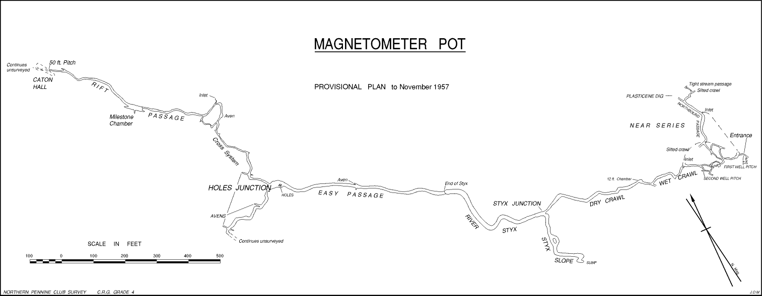
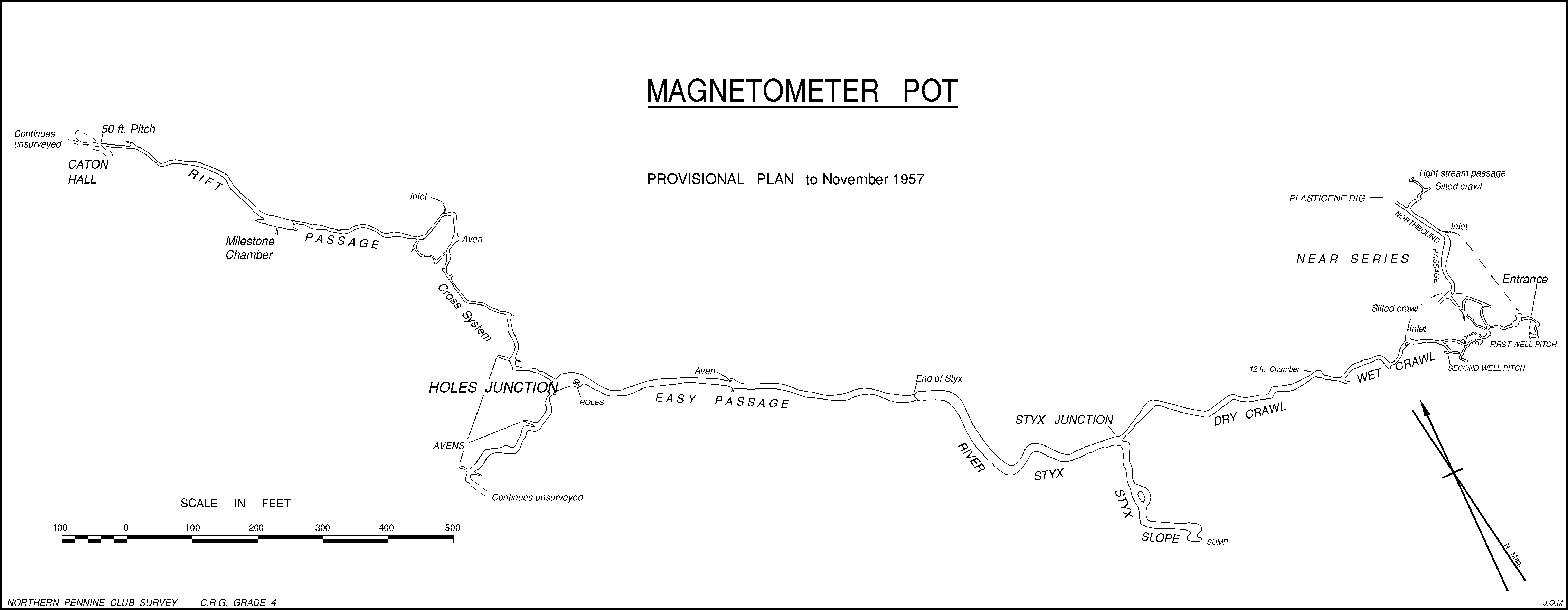
The following morning, B.Heys, R.T.Hylton, R.Smith and I continued to work at the entrance, trying to clear enough space to lift off one of the main slates. The first one was so large that we never reached its boundary, so we just chipped off enough to enable a man to get past. This work revealed the first of the railway lines, four in number and full gauge, which were neatly placed parallel to each other across the top of the hole. The area was neatly slabbed with one inch thick slates. This was only about four feet or so wide, while from the magnetic results, the lines appeared to be between twelve and fifteen feet in length, so that the site must have presented a very different appearance when the lines were first placed in position.
Another party, consisting of G.Batty, A.Fincham, C.Green, W.Holden and B.Hudson, who had been to the Wet Sink, returned in time to help with the good work. Batty and Smith went down through the lid and barred down several tons of loose boulders which were preventing access to the fifteen foot pitch below. Then more boulder shifting before a rope pitch of twelve feet in a rift was descended. Heys joined the other two below and soon a shout indicating that a stream passage had been entered was followed by the complete disappearance of the party from sight and sound. Meanwhile, the very unstable entrance shaft was made safer by the introduction of a couple of forty gallon oil drums, with ends removed, to make a shaft through the stream bed, and a third one added later to bring the top above flood level. Normally with a stream flowing past, this presents a most strange appearance, especially when someone is in the 'conning tower'.
The party down the rope pitch had virtually disappeared. When they had been gone for over an hour, it was apparent that there must be something interesting to detain them for so long, so the remainder of the party followed. Down the rope pitch, a simple winding passage soon led to a climb down in a chamber, down one side of which, recently shattered boulders indicated further clearing activities. Beyond here, the passage shrank to a hands and knees crawl leading into a fissure where a roof traverse was advisable and then via a four-ways junction and a narrow winding passage to a pitch. All this part was dry, the water having disappeared down a hole in the floor at the beginning of the first fissure. Here at the pitch we found the rest of the party gazing down what appeared to be a one hundred foot shaft into a deep pool. They asked us which way we had arrived there, and apparently there were already two routes of approach, one the way we had come, and the other a short cut that we had missed.
A return to the surface for tackle and then Fincham went down the pitch which proved to be 65 feet deep and the water too deep to stand up in, while there was no dry landing space. A ledge about twelve feet up looked as if it might give access to another shaft on the other side of a curtain wall. Batty went down and managed to swing onto the ledge and look into a parallel shaft also full of water. The water surface went round a corner out of sight and it was felt that a check with a rubber dinghy was advisable. This, when carried out a week later, revealed no way on above water level and the place subsequently became known as the First Well Pitch.
A few feet down the Well Pitch, a side opening led to another parallel shaft dropping to the same water level. From a short distance down here, a crawl passage was followed, which led off via a complex of small passages, up a small aven, and by another crawl, back to the First Well Pitch again. At the foot of the small aven was another pitch which was descended the following week by B.Heys supported by G.Batty. This, the Second Well Pitch, ended in a pool of water with the exit in a small crack below the surface. A.Fincham, investigating the far end of this dry crawl system, started off along a wet crawl of comfortable size. As no-one followed, he came back again, but it was continuing easily, although apparently in an upstream direction. While at the First Well Pitch, we noticed a strong air current disappearing in this direction, and began to wonder if there might not be an overhead route beyond the sumps of the Well Pitch series. The general direction was favourable but the attempt had to wait until the following week.
During the first day's exploration of the near entrance series, a passage system leading off at the Four-Ways was explored through some dry crawls to a phreatic-type passage of some five to six feet in height and six to eight feet in width occupied by a small stream. After a short distance, the main passage suddenly terminated in a clay choke, while the stream continued down a small winding passage which soon became too tight for individuals of normal size. A few yards down the smaller passage, a dry silted crawl led off to the right.
The first day's work, then, resulted in the descent of the First Well Pitch and the exploration of some three hundred yards or so of passage. Considerable confusion existed regarding the detailed layout of the crawls around the top of the First Well Pitch which could only be resolved by survey. However, the name Magnetometer Pot had now come into full use, though it was not long before the easier abbreviation of 'Mag' was preferred in general conversation.
On Sunday, May 12th, both exploration and survey went on at the same time. M.G.Riley, R.Smith and I started surveying the near series. G.Batty and B.Heys with A.Fincham, G.Gowland and B.Hudson checked the First Well Pitch by rubber dinghy. This proving to be a dead end, the latter two went off along the wet crawl while B.Heys and G.Batty examined the Second Well Pitch. The Well Pitch party drew blank, but the 'Wet Crawlers' were more fortunate. Pressing on for about fifty yards, they emerged from the water into a twelve foot high dry chamber. The way on was slightly downhill in a low dry crawl which gradually increased in height to hands and knees going, at the same time accompanied by a pleasing development of stalactite formations. After about 110 yards, this crawl opened at a T-junction into a much larger clean rock arched roof passage. They turned right here and proceeded north westwards in the apparent downstream direction, finding the twelve to fifteen foot wide passage gradually getting deeper and deeper into standing water, a section soon named the River Styx. At a point where waist deep wading was necessary, the roof appeared to be meeting the water not far ahead, but a few feet of weaving between massive roof pendants which dipped below the water surface, gave access to an easy continuation. A few yards more wading and they stepped out of the water and entered a completely different type of passage. The change at this point could best be compared with the change from the arched Cellar Gallery to the flat-roofed visitors' section as one comes out from Clapham Cave. In the case of the Styx the transition is direct, with no side-stepping as in Clapham Cave.
Some two hundred yards of clean washed passage, roughly ten feet square in section, led easily onwards until at a wider part it suddenly appeared to end. A way on to the right in a northerly direction, the Cross System, was followed until a narrowish stream passage was entered. The rock both in this and the Cross System was clean washed and highly eroded, apparently by fast-flowing water. After rather less than a hundred yards in the stream passage, they climbed down fifteen feet into a high rift cavern, Milestone Chamber. Although the passage at the far end beckoned them on they felt that perhaps they ought to leave a bit for others to explore and so turned back at this point.
When Fincham and Hudson returned with excited accounts of long marches towards Brants Gill and lots of formations, Heys and Batty could not resist having a look. They went on beyond Milestone Chamber and in only another hundred yards reached the top of a fifty foot pitch opening into a very large rift chamber, later named Caton Hall. They also had a look to the left at the junction at the start of the River Styx and found the large passage plunging down a steep slope to a small but sinister sump. The slope covered with sand and small gravel gave the impression that the sump could rise and flood the Styx and the crawls - perhaps 'Once in a century' as Heys put it.
Unable to wait for the next weekend, G.Batty, who had been advised by his doctor to rest for a day, joined R.T.Hylton and T.Marsden, temporarily men of leisure, and went down Magnetometer Pot again on Wednesday, May 15th. They descended the pitch into Caton Hall and were disappointed to find no broad highway out at the bottom. Opposite to the pitch, a huge slope of boulders went up nearly to the roof. No way could be found through the boulders. A restricted bedding plane entered through the boulders at the foot of the pitch was left until the weekend for a more thorough examination. The parties which had so far reached Caton Hall were agreed in their estimate of about half a mile distance from the First Well Pitch. This was later confirmed by the survey to be in error by not more than 2%.
Sunday 19th May saw another combined exploration and survey trip. While H.Dickens, W.Holden, R.T.Hylton and I surveyed slowly through the Wet Crawl and beyond, the exploration spearhead (Brants Gill Head or Bust!), consisting of B.Heys, G.Batty, R.Caton, A.Fincham, G.Gowland and B.Hudson, pressed on. Unfortunately as far as the exploration party was concerned it was 'Bust', and they were defeated after forcing about a hundred yards of particularly unpleasant rough wet crawl leading on beyond the bottom of the fifty foot pitch. The whole of this area bore unmistakeable signs of flooding to the roof. The survey party completed the main passage through the Wet Crawl and the Styx and on as far as the top of the pitch into Caton Hall. On the same trip, the rather obscure inlet passage coming in from the Southwest at Holes Junction was noticed and followed for some distance.
None of the party who had been down the crawls beyond Caton Hall had been particularly anxious to return there for some time, and in any case it was not a very safe area during the wet summer that followed. Attention was turned to the possibility of digging out some of the obvious choked passages which seemed to be leading off into new ground. The one on which most hopes of success were pinned was the Plasticene Dig at the end of Northbound Passage. The clay choke here had now been removed over a distance of about thirty feet and the passage continues as a practicable clay and sand dig with an occasional current of air to add encouragement. Work is also continuing at other points in the system and it can only be a matter of time and patience before new ground is broken.
[Web edition: A 300 dpi printable version of the 1957 survey is also available - be aware that this is 15.1 x 5.9 inches (38.4 x 15 cm) which is bigger than A4 paper.]
From the entrance at the top of the small pasture north-east of Fornah Gill Barn, the main trend of the cave is west-north-west. The River Styx passes under the wall almost due north of Fornah Gill Barn, bringing the cave into High Cow Close. The Easy Passage then leads on into Cow Close along a north-westerly line and then the northerly Cross System and north-west Rift Passage leads toward the north side of Cow Close. Just before reaching Caton Hall, the passage goes beneath the wall. The survey ends here at present, on the southern edge of New Pasture. The general trend of the cave is towards Silverdale Gill Pot and the depth from the entrance is about 150 feet, bringing the level of the far end to about 1150 feet O.D. The Northbound Passage would seem to be trending in a direction which would soon intersect the line of the Hammer Pot system if it could be continued, hence the keen interest in this area.
A thorough study of the development of the cave system of Magnetometer Pot has yet to be made. A few tentative observations can be made, however. The lowest points in the Near Series are down the First and Second Well Pitches, but the exits from these are at present flooded and impassable. The most important passages appear to be the crawls which are of phreatic or sub-water-table origin. From the Four-Ways Boulder, the Northbound Passage is heading for the general line of the Hammer Pot system and the water draining away along here is not seen again in Magnetometer Pot.
The Wet Crawl, an 'upstream' passage, leads to the Dry Crawl, a 'downstream' passage, finally reaching the Styx Passage. Here is a link with a much larger system which seems to be more actively developed than the Near Series. The River Styx continues as an arch-roof phreatic or sub-water-table type of passage which then suddenly changes its character to the square section of Easy Passage. At Holes Junction, this main way terminates abruptly. The way down the holes in the floor is at the moment too narrow to explore. The south-westerly passage now seems to be definitely an old inlet although hopes had been entertained that it might be a blocked continuation of the main way. The continuation to the north via the Cross System is of a much smaller cross-section than that of the Styx and the Easy Passage. The small inlet met at the beginning of the Rift Passage does not appear to be large enough to have formed the passage it is now using. This enlargement would seem to be mainly due to water coming along the Cross System from the Easy Passage. Very sharp erosion features in the limestone walls and floor of both these passages suggest very fast flowing water.
The 'Once in a century' floods from the small sump at the foot of the Styx Slope have been arriving at a frequency of several times a year. There have been at least three floods this summer which have redistributed the sand and gravel of the Styx Slope, and changed the water in the pools of the Easy Passage. The floods appear to come up the Styx Slope at a velocity sufficient to lift small gravel up to half an inch in diameter. Water fills the River Styx to the roof towards the far end and flows back through the Dry Crawl and the Wet Crawl and on into the Second Well Pitch. The main flow surges on down Easy Passage at a depth of between four and five feet. Some of the water must flow down the holes in the floor at Holes Junction filling up the restricted openings below completely, while the overflow continues north, now at roof level in parts of the lower passages. The flow is then able to move with less restriction down to Caton Hall, where it floods the low crawls beyond to roof level.
The last and most severe flood so far recorded probably occurred on Tuesday, 29th October. On Saturday, 2nd November, B.Heys and B.Hudson visited the Near Series and were intrigued to find a new foam tide mark round the walls four feet above the top of the First Well Pitch. The initial flood had come out of the crawl at a high enough velocity to move pebbles of over two inches in diameter. On looking down the pitch they were puzzled to find no reflection of the light in the pool at the bottom. Dropping a stone down revealed that there was no longer a pool at the bottom - the plug had come out ! A week previous to this, Hudson and I had observed that a rock floor was visible at the bottom of the Second Well Pitch, although on that day, the water down the First Well Pitch appeared to be at normal level. Both pitches were subsequently redescended, but there was still no way out at the bottom of either; the exits being waterlogged fissures.
The intermittent floods coming from a part of the pot which is normally inactive raise the problem of the origin of the water. The only certain thing is that this is not derived mainly from sinks in Fornah Gill as these are not capable of taking anywhere near sufficient water. The floods must be the overflow of some other nearby system which is normally carrying the stream, but which has a restriction causing flood water to back up excessively. These conditions could be fulfilled by Hammer Pot, the main drainage line of which lies barely 300 yards away to the north-east. The pool from which the stream flows down the Out Fell Master Cave in Hammer Pot is at roughly the same level as the foot of the Styx Slope in Magnetometer Pot. The present survey estimation would put the pool at the foot of the Styx Slope at about ten feet above that in Hammer Pot. Bearing in mind the limits of accuracy of the surveys so far as depths are concerned, these pools must be considered as being suspiciously near to the same level and the possibility cannot be excluded that they are connected by a submerged water system. Thus when heavy rain causes the flow to increase beyond the capacity of the restricted entry into Hammer Pot, the overflow passes through Magnetometer Pot. The question thus resolves itself into the ultimate origin of the stream in Hammer Pot.
Beyond the two potholes to the south-east lie the open slopes of Out Fell leading via Dick Close Pasture to Knowe Fell. The ultimate limit of the area draining to Brants Gill Head is not yet defined, but the first square mile of Out Fell can now be included as a result of fluorescein testing. This water must be draining via Hammer Pot, hence the name of the Out Fell Master Cave. In dry weather, not very much water sinks on Out Fell and parties who have been down Hammer Pot are agreed that even in dry weather the flow of water is such that it would be suicide to attempt to descend the last pitch of Hammer Pot direct with the stream. Thus the Wet Sink and Coates' Cavern have to be brought in to make up the difference. With this hypothesis, Hammer Pot becomes part of the missing Wet Sink Master Cave System and Magnetometer Pot, the present overflow, must be the original Master cave to Brants Gill head. The only positive material clue to support this hypothesis was provided on a survey visit to the Styx Slope after a flood. The receding water had left the slopes of sand and gravel covered by a top layer of about half an inch of little bits of heather shoots and twigs, fragments from the peat. These are not produced in volume by the numerous small trickles which form the drainage of Out Fell and beyond, but rather from the rapidly eroding peaty banks of raging torrents such as the two becks which contribute their water to the Wet Sinks system.
Although exploration is temporarily halted, there are three areas of interest where further work needs to be done. The first in Northbound Passage is the continuation of the Plasticene Dig which is suitable for wet weather work. Thin men may make more progress in the streamway and the small silted crawl near here. The possibilities of the partly flooded fissure down the holes in the floor at Holes Junction should not be ignored. Finally, in the next dry spell in the spring of 1958, it is intended to have another determined push at the end of the crawl beyond Caton Hall. On the surface, the natural inclination would be to examine possibilities nearer to Brants Gill Head in the hope of bypassing the obstructions in Magnetometer and Hammer Pots.
The grateful thanks of all concerned in the exploration are due to Mr.H.Caton of Neals Ing for permission to excavate in Fornah Gill and particularly for bringing to our notice this wonderful opportunity of rediscovering a lost pothole.
[ there should be a diagram here, but as we no longer have a printed copy of the Black Journal to scan them from, they are missing for the time being]
Profiles showing variation of the vertical component of the earth's magnetic field over the concealed railway lines in Fornah Gill, Fountains Fell.
![]() NPC Black Journal 1957:
NPC Black Journal 1957:
![]() Next page: Scaling Ladders in Lancaster Hole
Next page: Scaling Ladders in Lancaster Hole
![]() Back to contents
Back to contents
![]() Previous page: Caving in Austria
Previous page: Caving in Austria
![]() Out of print publications list
Out of print publications list
![]() Northern Pennine Club Home page
Northern Pennine Club Home page